Shaw Point—Although it may seem exaggerated, the sun in Interior Alaska is indeed relentless. In June, northwest of Delta Junction, daylight lasts nearly 21 hours. Night is limited to a brief period of twilight as the sun descends just beneath the horizon before rising again. While temperatures only reached the low 80s, the continuous sunlight produced a cumulative effect. Summer days in Alaska are longer, not due to the clock, but because the light is constant.
I know a bit about this because I have lived in Alaska for the past eight years. I am an artist and educator teaching photography and digital art at Bartlett High School in Anchorage. Since moving from Texas, where I was teaching as an adjunct instructor at various institutions, I have spent much of my time trying to understand the ecology, geology, and history of this place. I became interested in participating in a Polar STEAM expedition in Alaska to continue discovering my adopted state.
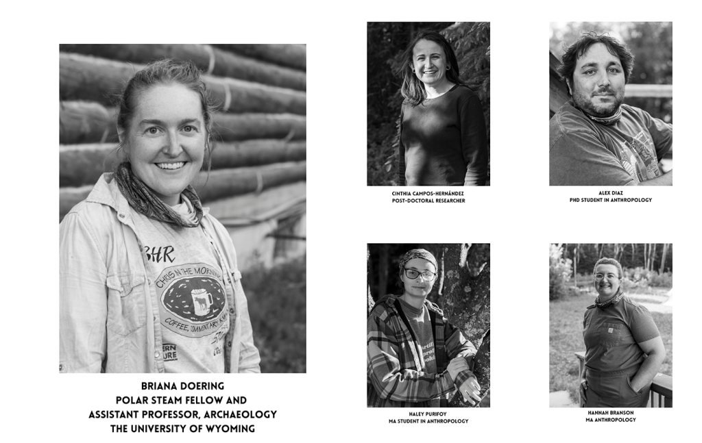
Our research team at Shaw Point was led by Dr. Briana Doering (who goes by Bree). Working alongside her were graduate students and researchers investigating different aspects of the site. Cinthia Campos-Hernández and Haley Purifoy study the use of ancient plants. Alex Diaz focuses on the role of salmon in subsistence strategies through ancient sites, while Hannah Branson explores evidence of children in the archaeological record and what it may reveal about childhood thousands of years ago.
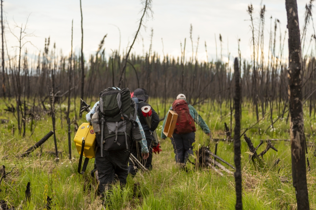
For a week and a half, we worked on top of Shaw Point, a small rise surrounded by wetlands and bogs. The forest around us had burned during a lightning-caused wildfire in 2023. Blackened spruce trunks lay dispersed across the site like a massive game of pick-up sticks, and not a single tree on the crest of the rise had survived the fire. Some still stood upright, skeletal and gray, creaking faintly when the wind moved through them. Shortly after the fire, the site might have been described as desolate, but life was already returning. Grasses and young plants were beginning to reclaim the ground, and the smell of smoke lingered only when you grazed a dead trunk or disturbed the charred bark.
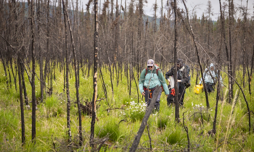
Our typical day started early. We packed lunches, made coffee, and drove toward the Pogo Mine Road. After checking in at the security gate, we hiked nearly 45 minutes through wetlands and muskeg to reach the site. Some sections of the trail were ankle-deep in water. Xtratufs proved invaluable!
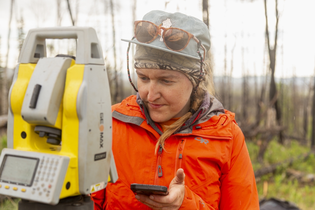
Upon arrival at Shaw Point, the work commenced: excavation, surveying, screening, recording, and documenting. The pace fluctuated, sometimes slower or faster than anticipated. Archaeology proved to be both a highly collaborative and a physically demanding task.
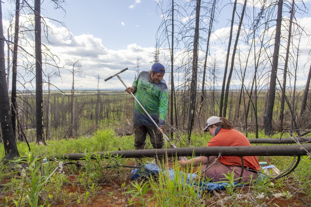
Before opening an excavation unit, the team needed evidence that people had actually occupied the site. One of the methods Bree brought from her work at the University of Wyoming is systematic auger testing. An auger is essentially a large hand-operated soil corer that allows researchers to sample the ground without opening a full excavation. At Shaw Point, the team laid out a grid and dug a series of auger holes across the landscape, documenting the precise location and contents of each test. The process provides a much more systematic way of locating areas likely to contain archaeological material.
Bree initially implemented this approach at Shaw Point during her previous field season two years prior and expanded the testing during our visit. In discussing the results, she noted that this year’s discoveries validated the method. Areas identified through the auger survey yielded cultural materials and features when excavation units were subsequently opened. Observing this process led to a better understanding of how archaeology integrates instinct with systematic data collection. The discoveries in the excavation units originated not from a trowel but from a deliberate effort to understand the landform through incremental sampling.
Many of the auger locations were buried among dense tangles of burned trees, making access difficult. While the archaeology team focused on auger testing, I took on clearing paths through the deadfall. The work was physical–cutting fallen tree trunks, moving logs, and climbing over piles of tangled spruce. We brought two battery-powered chainsaws and quickly worked through both sets of chainsaws and batteries each day.
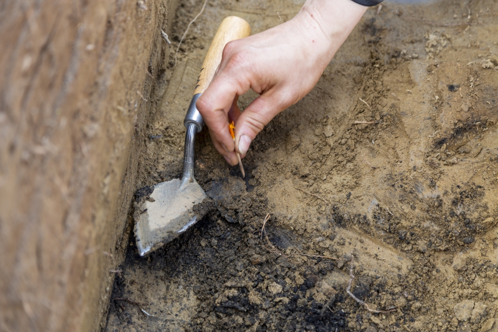
Excavating a site calls for precision. Every corner is surveyed, each unit measured and remeasured, and every artifact larger than a centimeter is documented and mapped. The excavation walls are maintained straight and level, producing a cross-section through time. Although the tools are simple—trowels, brushes, screens, buckets—the accuracy achieved is remarkable. What may appear as a simple hole is, in reality, a complex archive of information. Observing the team, I realized that archaeology is seldom about discovering a single spectacular artifact. Instead, it is the accumulation of numerous small observations and pieces of evidence that enables researchers to construct possible narratives about the past.
The real excitement began on day five of our expedition. I found myself looking through my camera over the edge of the vertical excavation wall as Cinthia Campos-Hernández, a post-doctoral researcher at the University of Wyoming, methodically drew a trowel across the soil of the small excavation unit. During this Polar STEAM expedition, I learned that archaeologists rely on listening as much as observation. The sound of metal scraping against stone flakes can indicate a buried artifact. Layer by layer, Cinthia removed soil, paying close attention to the tactile and auditory feedback of each trowel stroke, until the earth began to darken. The stain, initially a faint discoloration, became more visible with each pass, ultimately revealing evidence of fire.
The dark stain expanded into what appeared to be an ancient cooking feature, eventually measuring more than a meter across and spanning two units. A unit refers to a 1-meter-by-1-meter excavation area, typically excavated in 10-centimeter levels. This discovery was a key moment for the team, providing evidence that Bree’s projected models, auger testing, previous excavations, and years of research had accurately identified an area occupied during the Late Pleistocene, approximately 14,000 years ago.
As a photographer, I am interested in the construction of narratives. Photographs act as fragments that viewers assemble into stories. Archaeologists engage in a similar process, gathering fragments of evidence to reconstruct lives, movements, decisions, and cultures from what remains.
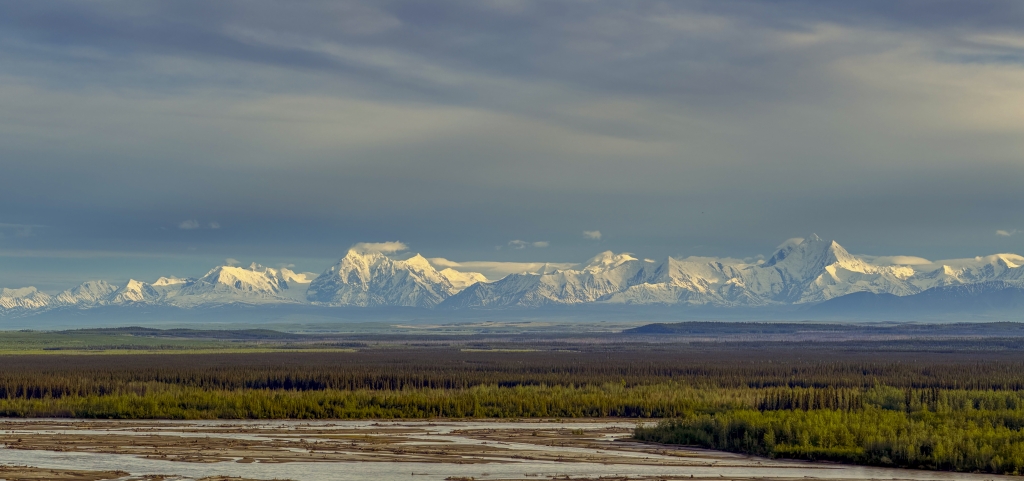
Looking out over the land, I tried to imagine that world. At first, I focused on what was missing. The mixed forest that now surrounds Shaw Point would not have existed. The recognizable landscape I was standing in started to dissolve. As I looked more closely, my attention turned to the individual elements that remained: the wetlands surrounding the site, the burned trees scattered across the rise, and the broad course of the Tanana River winding through the valley below. Bree and I discussed that the river had likely shifted closer to and farther from Shaw Point many times since people first camped here.
Archaeology provided a means to glimpse these earlier landscapes. The excavation units revealed traces of fire, stone tools, animal remains, and buried surfaces, each signifying a distinct moment of occupation. Although the evidence was fragmentary, it suggested generations of people who knew this place intimately. Standing on Shaw Point, I began to feel disconnected from the present landscape and drawn toward a world accessible only through fragments of evidence and imagination.
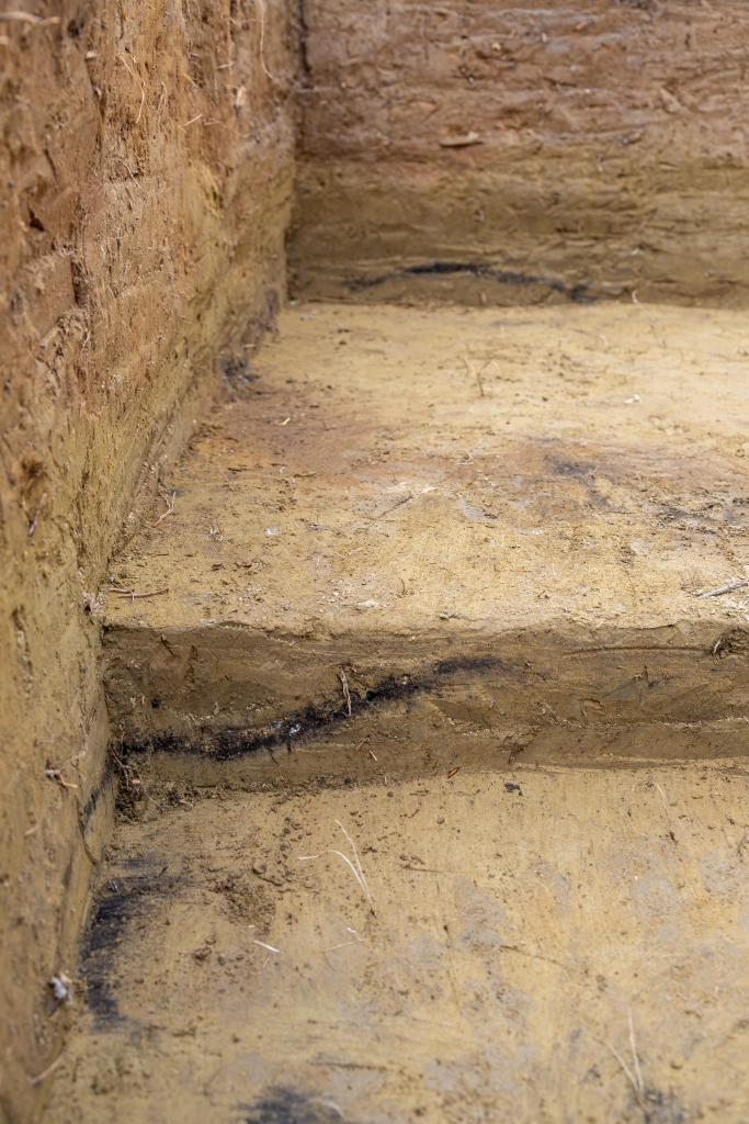
One photograph from the trip continues to occupy my thoughts. It shows two excavation units cut deep into the ground, their walls exposing layers of soil deposited over thousands of years. Near the bottom of each unit is a dark burn layer–the remains of an ancient fire. When I made the photograph, that burn layer was what caught my attention. I wanted to show how the feature extended across both units, connecting them and revealing the Late Pleistocene ground slope.
Only later, during the editing process, did I realize the true subject of the photograph. The burn layer was merely one aspect. The excavation walls displayed bands of soil in varying shades of brown with two black strips along the lower section of the wall, each pointing to a distinct moment in time. The image condensed thousands of years into a single frame. What initially appeared to be a photograph of a fire feature became, instead, a photograph about time itself.
As a photographer, I am often interested in the ways images collapse time and space. Here, the excavation wall did that quite literally. Each layer signified a period of accumulation, change, stability, or disturbance. Together, they formed a visual record of habitation and landscape history that could be read much like a timeline.
Yet what interests me most about the photograph is what is missing. The people who built the fire are absent. Their stories, names, relationships, and daily lives have long since disappeared. What remains are traces: charcoal, soil, flakes of stone, fragments of bone. Without the people, the photograph becomes evidence of absence. It shows that someone was here, that they lived and worked on this rise above the Tanana Valley, but it leaves the details to be reconstructed by archaeology and imagination.
The longer I examine the image, the less I perceive an excavation unit and the more I recognize a portrait of time, memory, and inhabitation. It functions as a reminder that landscapes are not only places; they are archives, layered with evidence of the people who traversed them, shaped them, and left traces of themselves within the earth.
When I was a child, and we traveled somewhere new, my mother had a habit of tapping me on the top of the head and saying, “Look up.” I can still feel her fingernail tapping on my scalp. It is one of those physical memories that has never left me. Whether we were visiting a city, hiking through a park, or standing in front of a building, her reminder was always the same: look up.
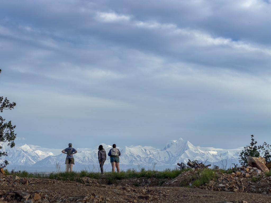
Perhaps because of that, I have spent much of my life looking toward the horizon. As a photographer, I have been drawn to mountains, weather, clouds, and distant landscapes. My work often asks viewers to consider vast stretches of time and space. The horizon line was the defining feature of my childhood in West Texas, and I suspect I have been following it ever since.
Archaeology requires a different kind of attention. Instead of looking toward the distance, archaeologists look down. They study fragments, traces, and subtle changes in the soil. A flake of stone, a stain of charcoal, a piece of bone no larger than a an 1/8 of an inch can completely alter the understanding of a site. Meaning is built not from sweeping vistas but from careful observation of small details.
As the week proceeded, I found myself doing the same. My attention shifted from the broad landscape to the ground under me. I began noticing textures in the soil, variations in sediment, the sound of a flake on the screen, the feel of a bone under my finger tip, and the edge of a burn layer emerging from the excavation wall. The work encouraged a slower way of seeing.
I do not believe I will ever stop looking up. The mountains, rivers, and skies of Alaska continue to captivate me. However, Shaw Point demonstrated that landscapes are not solely experienced across the horizon; they are also layered beneath our feet. The excavation provided only a limited look into the past, yet this experience changed my understanding of place. The land possesses its own memory, and we must learn to interpret it.